Four Days of Riding in Western Montana’s Glacier Country
When it comes to riding the open roads of Montana on a motorcycle, Western Montana’s Glacier Country has the most miles of well-maintained roads in the Treasure State. And with fresh Rocky Mountain air to breathe and winding roads—many which follow river bends—it’s easy to connect to the spirit of Montana and find a “wow” around every corner.
Day 1: Missoula to Bigfork
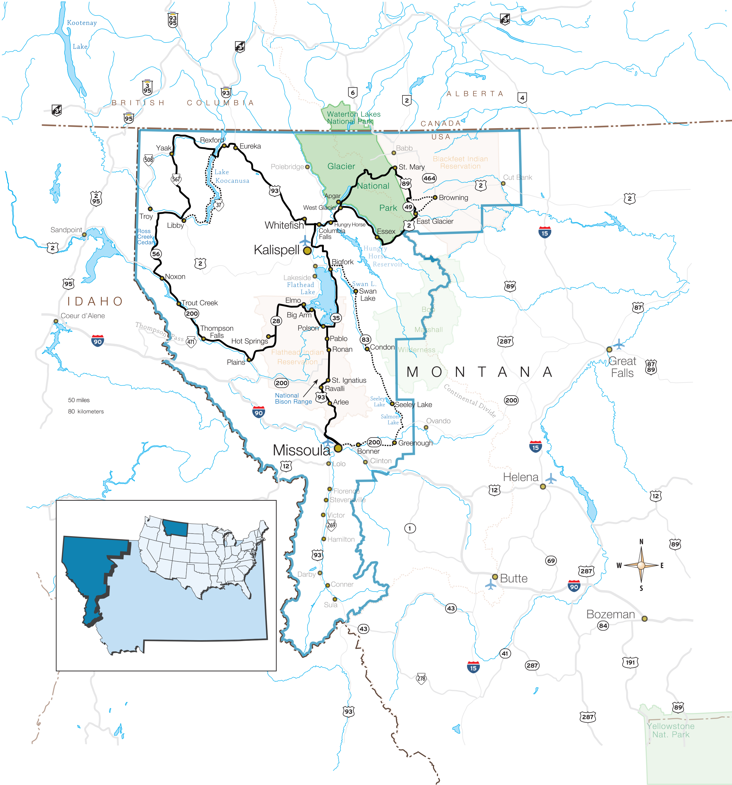
After arriving into Missoula International Airport, pick up your rental motorcycles at Grizzly Harley-Davidson in Missoula (1.8 miles from the airport). Begin your Montana adventure by riding north on Highway 93.
Stop in the town of St. Ignatius at the Three Chiefs Cultural Center and learn about the rich cultural heritage of the Salish, Pend d’Oreille and Kootenai tribes. The center features an exhibit gallery and gift shop focused on American Indian heritage, natural history and cultural interpretation.
Located adjacent to Ninepipe National Wildlife Refuge (home to more than 2,000 acres) is Ninepipes Museum of Early Montana. The museum has a collection of early photos, artifacts and antiques that represent more than a century of life in the Flathead Valley and the Flathead Indian Reservation.
As you drop into the town of Polson you will capture another breathtaking view of Flathead Lake—the largest natural freshwater lake in the West. Attractions in Polson include the Miracle of America Museum and its amazing collection of vintage motorcycles, including a 1917 Harley Motorcycle Racer and a 1941 Indian 4 Cylinder Motorcycle.
Head up the east side of Flathead Lake toward Bigfork (35 miles) on Highway 35 for some spectacular riding and breathtaking scenery. Stop off at one of the roadside fruit stands and enjoy some fresh and locally grown Flathead cherries.
Overnight in Bigfork.
IF YOU GO:
Grizzly Harley-Davidson - 406.721.2154 - grizzlyhd.com
CSKT Bison Range - 406.644.2211 - bisonrange.org
Ninepipes Museum of Early Montana - 406.644.3435 - ninepipesmuseum.org
Three Chiefs Cultural Center - 406.675.0160 - threechiefs.org
Miracle of America Museum - 406.883.6804 - miracleofamericamuseum.org
Polson Chamber of Commerce - 406.675.0160 - polsonchamber.com
Bigfork Chamber of Commerce - 406.837.5888 - bigfork.org
SLEEPS:
Bridge Street Cottages - 406.837.2785 - bridgestreetcottages.com
Timbers Motel - 406.837.6200 - timbersmotel.com
Wayfarers State Park - 406.88702715 - stateparks.mt.gov/wayfarers
EATS & WATERING HOLES:
Flathead Lake Brewing Co. - 406.837.2004 - flatheadlakebrewing.com
Echo Lake Cafe - 406.837.4252 - echolakecafe.com
The Garden Bar - 406.837.9914
Alternate Route: Missoula to Bigfork via the Seeley-Swan Valley (Highway 83). Thick pine forests, charming small towns, and mountain lakes are scattered throughout the ride, providing excellent places to stop and take in the scenery. On the east side of the road, you will see the jagged peaks of the Bob Marshall Wilderness. On the west side, you will see the eastern slope of the beautiful Mission Mountain Range. (154 miles)
Day 2: Glacier National Park
Head out of Bigfork (via Highway 35 & Highway 206) to West Glacier (39 miles from Bigfork).
At West Glacier you begin the amazing journey over the Going-to-the-Sun Road in Glacier National Park. If you see nothing else in the state of Montana, this 50-mile-long road that takes travelers through the heart of the park is a must. Along the way you’ll see incredible views of glacial-carved valleys, jagged peaks and pristine wilderness.
Designated as a National Historic Landmark in 1997, the road is as beautiful as it is challenging. Small shoulders, sharp turns and dramatic climbs to Logan Pass (6,646 feet) make this a route for experienced riders.
Optional add-on: From Glacier National Park, drive north across the Canadian border (passport required) to visit the Waterton-Glacier International Peace Park. Established in 1932, it was the world’s first international peace park, created to commemorate the bonds of peace and friendship between the US and Canada. The conjoined park is a United Nations World Heritage Site. Check out the beautiful Prince of Wales Hotel, a rustic grand hotel built in 1927 (43 miles from St. Mary).
After a stop at the Park Café in St. Mary for pie, head south on Highway 89. Take the cut-off road between Kiowa and East Glacier Park (Highway 49) for some fabulous views into the Two Medicine Valley. Continue west to check out historic Glacier Park Lodge in East Glacier Park. Built in 1912 by the Great Northern Railroad the lodge is nestled at the foot of Dancing Lady Mountain. Grab dinner at Serrano’s Mexican Restaurant—it’s definitely worth a stop. Continue east on Highway 2 to Whitefish.
Optional add-on: Ride to East Glacier Park via Browning, the largest community on the Blackfeet Indian Reservation. Browning attractions include the Museum of the Plains Indian and the Lodgepole Gallery.
Overnight in Whitefish (81 miles from East Glacier Park). Don’t miss the bar the locals love, The Great Northern. And for breakfast, fuel up at The Buffalo Café or Loula’s.
IF YOU GO:
West Glacier - 406.888.5403 - westglacier.com
Going-to-the-Sun Road + Glacier National Park- 406.888.7800 - nps.gov/glac
Whitefish Convention & Visitors Bureau - 877.862.3548 - explorewhitefish.com
Whitefish Mountain Resort - 406.862.2900 - skiwhitefish.com/summer
EATS & WATERING HOLES:
Park Café - 406.732.4482 - parkcafe.us
Serrano’s Mexican Restaurant - 406.226.9392 - serranosmexican.com
Buffalo Café - 406.862.2833 - buffalocafewhitefish.com
Great Northern Bar - 406.862.2816 - greatnorthernbar.com
SLEEPS:
Best Western Rocky Mountain Lodge - 406.862.2569 - rockymtnlodge.com
Pine Lodge - 406.862.7616 - thepinelodge.com
Whitefish Lake State Park - 406.862.3991- stateparks.mt.gov/whitefish-lake
Day 3: Whitefish to Thompson Falls
Head north on Highway 93 to the charming town of Eureka, located just five minutes south of the Canadian border. Formerly known as Tobacco Plains, the Eureka area was originally home to the Kootenai Indians. David Thompson was the first whiteman to see the area in 1808 and homesteaders began to arrive in the 1880s. (50 miles from Whitefish)
Ride through Rexford (5 miles from Eureka) to Lake Koocanusa, a 90-mile-long reservoir behind Libby Dam. 50 miles of this reservoir lies in the United States while the other 40 miles are in Canada. The roads on either side of the lake make a wonderful riding loop with beautiful views of both sides of the lake. This loop, through the forest along State Highway 37 and the Forest Development Road (FDR) 228, was designated a Scenic Byway in 1992. The lake cuts a narrow fjord-like gorge between the Purcell Mountains and the Salish Mountains. (67 miles from Eureka to Libby)
From Libby, the Lake Koocanusa Scenic Byway (Forest Development Road No. 228) travels around the west side of the lake and is a more leisurely, two-lane, paved route. Plus, you’ll pass through some of the most scenic wild roads in the northwest. This is heavily forested terrain with an abundance of wildlife. Visit Libby Dam (17 miles from Libby) and its visitor center to check out their exhibit area, book/gift sales area and auditorium featuring “The Power and Beauty of the Kootenai, the Story of Libby Dam.”
Follow Highway 567 to Yaak, Montana’s northwestern most town. Drop by the infamous bar “The Dirty Shame Saloon” and the Yaak Mercantile. Check out scenic Yaak Falls, cascading down in a beautiful narrow mountain valley, a photographer’s delight.
When Highway 567 meets Highway 2 (29 miles from Yaak), ride toward Kootenai Falls, located between Libby and Troy at milepost 21. The Kootenai River enters a canyon and flows over Kootenai Falls, one of the largest free-flowing waterfalls in the northwest. The falls and surrounding area are considered sacred to the Kootenai Indians whose ancestors inhabited the region. A forest trail leads from the highway parking lot down to the swinging bridge and makes a nice, easy hike. Interesting tidbit: Kootenai Falls was the setting for the filming of the movies The River Wild and The Revenant.
Take Highway 56 through the Cabinet Mountain Wilderness area and check out Ross Creek Cedar Grove. Home to an ancient forest of western red cedars, many of the trees are hundreds of years old and are more than eight feet in diameter. An interpretive walking tour, slightly less than one mile in length, explains the area ecology and history.
Ride toward Noxon where Highway 56 hits Highway 200. Noxon is located along the Clark Fork River in a densely forested mountainous area. Although the area was developed as a result of logging and mining, it is renowned for its hunting and huckleberries. Check out Toby’s Tavern in Noxon.
Continue on through Trout Creek for an overnight in Thompson Falls (91 miles from Libby). Thompson Falls, established in 1885 during the gold and silver mining era, sits in a quiet valley along the beautiful Clark Fork River.
IF YOU GO:
Eureka Chamber of Commerce - 406.889.4636 - welcome2eureka.com
Libby Dam - 406.293.7751- nws.usace.army.mil
Thompson Falls Chamber of Commerce - 406.827.4930 - thompsonfallschamber.com
EATS & WATERING HOLES:
The Dirty Shame Saloon - 406.295.5439 - yaakdirtyshame.com
SLEEPS:
Falls Motel - 406.827.3559 - thompsonfallslodging.com
Thompson Falls State Park Campground - 406.752.5501 - stateparks.mt.gov/thompson-falls
Day 4: Thompson Falls to Missoula
Take Highway 200 to Plains, turn onto Highway 28 and ride to Elmo, on the western shore of Flathead Lake (73 miles from Thompson Falls to Elmo).
You’ll want to take a short side trip off of Highway 28 to visit Hot Springs. Founded in 1910, it is named for the local hot mineral springs that still bubble today. Check out Symes Hot Springs and Fergie’s Pub.
Head south on Highway 93 to Missoula (98 miles from Elmo to Missoula).
While in Missoula, visit the Smokejumper Visitor Center (.8 miles from airport). As the largest active smokejumper base in the nation, the center provides a unique opportunity to learn about this unusual, demanding and dramatic occupation. (one hour guided tour)
A bit further down the road toward Missoula, stop in at The Rocky Mountain Elk Foundation’s Visitor Center (3.7 miles from Smokejumper Center). The center celebrates the conservation of public wildlands, working ranches and forests where elk herds can thrive. (one hour self-guided tour)
Enjoy one of the several downtown Missoula eateries and saloons. While enjoying the Clark Fork River views at Caras Park, you’ll notice nearby Brennan’s Wave—a man-made whitewater play area for kayakers.
IF YOU GO:
Hot Springs Chamber of Commerce - 406.741.2662 - hotspringsmtchamber.org
Smokejumper Visitor Center - 406.329.4934 - fs.usda.gov/science-technology/fire/smokejumpers/missoula/center
Rocky Mountain Elk Foundation’s Visitor Center - 406.523.4545 - rmef.org/contact/visitor-center
Missoula Downtown - 406.523.4238 - missouladowntown.com
EATS & WATERING HOLES:
Symes Hot Springs Hotel and Mineral Baths - 888.305.3106 - symeshotsprings.com
Fergie’s Pub - 406.741.2416
Biga Pizza - 406.728.2579 - bigapizza.com
SLEEPS:
Comfort Inn University – 406.549.7600 - choicehotels.com/montana/missoula/comfort-inn-hotels/mt082
Broadway Inn – 800.286.2316 – broadwayinnmissoula.com
OTHER RESOURCES:
Montana scenic motorcycle rides & safety information: ridemt.com
Montana safety information: mdt.mt.gov/visionzero/plans/motorcycle.shtml


